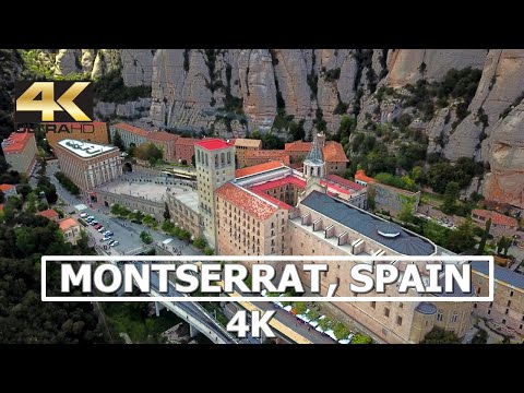
Nestled in the heart of Catalonia, Spain, Montserrat is not just a geological wonder but also a significant cultural and spiritual landmark. The majestic mountain range rises dramatically from the lowlands of central Catalonia, offering vistas that are both rugged and mystically serene. With the advent of drone technology, capturing the grandeur of Montserrat in 4K has provided viewers around the world with an unprecedented view of its unique topography and historical treasures. This article explores the stunning visual journey of Montserrat through the lens of a 4K drone.
#### The Geographical Majesty
Montserrat, meaning “serrated mountain” in Catalan, stands true to its name with multi-peaked rocky ranges that resemble the teeth of a saw. The highest summit called Sant Jeroni, reaches over 1,200 meters (about 4,000 feet) above sea level and offers panoramic views stretching from the Pyrenees to the north to the Mediterranean Sea to the east. A 4K drone captures these peaks with remarkable clarity, highlighting each crevice and cliff that forms this spectacular natural fortress.
The composition of Montserrat is primarily pink conglomerate, a form of sedimentary rock which is visually stunning when seen from above. The color variations and formations become vividly clear in high-definition footage; aerial views showcase winding trails that cut through lush greenery leading up to starkly contrasting rocky outcrops.
#### Spiritual Heartbeat: Santa Maria de Montserrat Abbey
Perched precariously halfway up the mountain is the Santa Maria de Montserrat Abbey. It has been one of Spain’s most important pilgrimage sites for hundreds of years because it purportedly houses La Moreneta (‘The Black Madonna’), Catalonia’s favorite saint. A 4K drone captures not only the grand scale and isolated beauty of this Benedictine monastery but also details like its Gothic architecture and Renaissance façade.
Drone footage often begins with sweeping shots that encompass distant views of the monastery situated against Montserrat’s jagged backdrop before moving closer to reveal intricate architectural features and bustling activity around this religious site.
#### Flora and Fauna from Above
The ecological diversity captured by drones at Montserrat is striking. The mountain supports microclimates ranging from lush lowland forests to barren higher altitudes. High-resolution aerial images display diverse vegetation patterns shifting dramatically with altitude changes on upwards sweeps along cliff faces.
Inhabiting these climates are various species that can sometimes be glimpsed through drone footage — wild goats navigating steep rock faces or birds such as eagles riding thermal currents high above.
#### Visitor Experience Enhanced by Technology
For visitors planning their trip or researchers studying its terrain, drone footage can provide invaluable insights into what areas to explore or focus on. Detailed previews let tourists gauge difficulty levels of hiking paths or locate viewpoints with optimal scenic vistas not visible from ground level.
Furthermore, virtual tours featuring drone videos offer an accessible alternative for people unable to physically visit due to mobility issues or global travel restrictions — extending Montserrat’s reach worldwide.
#### Conservation Implications
While drones capture mesmerizing images enhancing our appreciation for such landscapes, it’s crucial they’re operated responsibly without disrupting wildlife or violating privacy norms set by local authorities at protected sites like Montserrat.
In conclusion, exploring Montserrat through a 4K drone offers an extraordinary perspective on one of Catalonia’s most prized locales combining historical richness with natural splendor impeccably captured in every frame shot from above. As technology progresses so does our capability to admire and preserve these wonders for future generations — all from a bird’s-eye view that continues to astonish and inspire.
